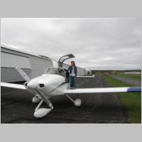
Weekend Getaway to Atlanta / Orlando
Trip Completed 10/14/07Total Time after Trip 284.4 hrs
|
The
Plan...or Lack Thereof
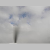
With a 4-day weekend to play with, we decided it was time
to get back in the cockpit for some fall travels. In the hot
summer months, we've been spending our time doing more water-based
activities so we've been yearning for time that we could coordinate
into a trip. Our first plan had been Maine, but the weather
wasn't cooperating for a pleasant trip, so we decided to head South.
The beauty of traveling in an RV-10 based in Wisconsin is you can be in
almost any region of the US in one day if you want to. While not the
barn burner you can have with a new Mooney or Columbia cruising in the
230-240Kt range (at a MUCH higher operating cost), the RV-10 is a very
capable x/c plane. We had no plans, other than to start by going to
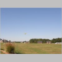
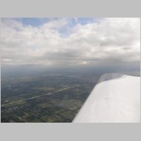
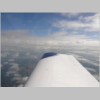
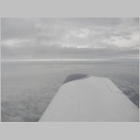
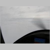
visit Vic in Atlanta, and then take it from there. You'll notice from
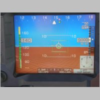
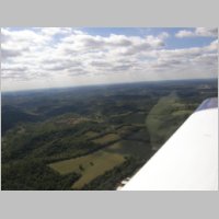
the first photo below that the weather wasn't necessarily great for
travel if you were a VFR-only pilot. It was bumpy and cool below the
clouds. However, after a short IFR climb through, we were pleased
to see very comfortable cruising at 9,000' with plenty of cloud
clearance, and absolutely smooth air. On this trip I flew almost all
legs, with the exception of one short 50nm leg, on an IFR plan, filed
using "RV10/G". |
|||
 |
 |
 |
 |
|
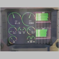
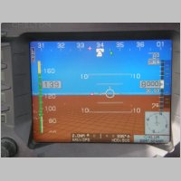
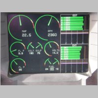
Cruising Economically
After completing the climb and adjusting the power
settings for my normal LOP (Lean of Peak) cruise, you'll see that the
Range worked its way up near 1000nm. When checking the True
Airspeeds below, keep in mind that my TAS has a known error that places
the actual TAS about 2kts higher than what the instruments
display. So initially we were cruising at about 159kts on
10.1gph. On this trip I pulled the mixure back a little further LOP
than on most previous trips, deciding to see if I could keep it around
10gph for the entire flight as an average. A note about the fuel
totalizer....I've spent a couple long x/c flights calibrating the
flowmeter and it is now so accurate that I'm usually within .1 or .2
gallons over an entire 45 gallon top off. So the readings here are
about as close to true as you can get. I did take a few minutes on this
trip to push the mixture forward to a ROP cruise setting, bringing
14.5-15gph, and airspeeds increase a little over 10kts when you cruise
that way. That's an awful lot of gallons of fuel though to get those
extra 10 kts. To put it in perspective, for the entire trip down near
Orlando, I'd save about 20 minutes of time by cruising ROP, but I'd
burn 25 gallons additional fuel to save the 20 minutes. How would
you feel if your fuel flow for some portions of flight ran 75 gallons
per hour for 20 minutes of the flight? Well, that's the effect of ROP
cruise on this flight. So considering fuel burn from LOP, I saved about
$186 on this flight alone in fuel costs from LOP operation. I'll write
more on the economy side towards the end.A note about static error causing my TAS reading low: I'm not sure if it's static error, pitot error, or something else that causes my 2kt discrepancy, but 2kts is close enough for me. I did find an interesting thing out on this trip. I finally checked out my alternate static port in-flight. Opening the alternate static causes an increase in altitude and an increase in indicated airspeed. What was funky about it this time was I had my autopilot on in smooth air when I checked it. Talk about surprise! One second you're cruising along level, but once your Autopilot (which has pitot and static inputs) or your EFIS gets that altitude change sensed, it's going to pitch over to try to maintain altitude. I had disengaged GPSS/GPSV and stuck the AP on Altitude Hold only, but I didn't account for the fact that the AP would sense it and dive. Nothing major, but I thought I'd point out the effect just for laughs. |
|||
 |
 |
 |
 |
|
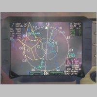
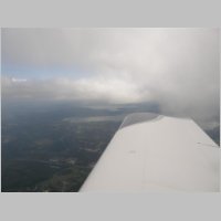
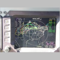
Good to have Wx
Enroute I had the first really long X/C flight with the
new WSI AV-300, and I'm pleased to report that it operated perfectly
the entire time. It was definitely a trip that ended up showing the
value of in-cockpit Wx. You can see above that I was able to
check on the existing airmets and sigmets and read through the text
during the trip, which I find very handy. These are features of the
premium Wx service. WSI's
current pricing model for the AV-300 is $29/mo for the basic
features, and $49/mo for the full feature set. I opted to start with
the full set and trim them back next year if I find I don't use the
expanded features enough. Textual Airmets/Sigmets are one of the
premium features, and so are winds & temps, which I also found
useful on this trip, so I'm probably looking at continuing with the
premium plan if this trip is any indication. One nice thing is that
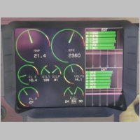
TFR's are now included with either plan.You may notice that by bumping up the fuel flows to 10.4gph, I added a couple extra kts to the TAS, now pushing 163 kts after accomodating the known error. Not bad for cruising at those fuel flows. Looking at the Oil Temps though, it's looking a bit low at 169, and my CHT's are very comfortable indeed, with the high one being 345 degrees. On the one datalink page below, you can see the reason why we didn't want to go to Maine...that mass of weather wrecked things for a couple days of our short 4-day weekend. |
|||
 |
 |
 |
 |
 |
 |
 |
 |
|
A comfortable cruise with good stops
Pointing out something for the RV-10 crowd, above you'll
notice the reason why I'm not a fan of split-70/30 or 80/20 rear bench
seats for the rear. Abby came up with a nice seat-filler for between
the rear seats right around OSH time, and it allows you to choose a
flat bench seat filler, an armwrest, or an armwrest with cupholders,
all with a filler panel for the seatbacks as well. The nice part is,
you don't lose access to the tail with the arrangement she made. Even
the standard seatbacks are pretty tall, so you won't find easy access
into the baggage area over the top.After a bit of cruising, we landed at our planned fuel stop for what was to be reasonable fuel...at 3M7. Too bad when we arrived the fuel pumps were locked up and nobody was there, despite the business hours posted showing they'd be open. Then one of my pet peeves came up...there were 2 after-hours phone numbers posted by the pump, but they didn't include any area code. Now how's a guy from out of town supposed to just know what the area code is? If you see this at your local FBO, tell them to get real and post all 10 digits. Too bad all I got was voicemail on one number, and the 2nd was disconnected. Well, off to the next place with reasonable fuel....KRNC! Again I should interject that this was the first trip I took where I used Voyager for all my flight planning, and my in-flight tracking. I found it very nice that it had downloaded and saved all the fuel prices along my route, so when I needed an alternate fuel stop, I was still able to pick and choose the best choice for me. That's what led me to KRNC. To top it all off, when I got to KRNC I was told that the fuel price "just changed yesterday"....and I thought "ok, well here I go again", expecting a big increase. Nope, not this time...the price had just DROPPED to $3.63! In fact, using their fuel planner I was able to pick fuel stops where the highest price I paid was at KLEE at $3.84/gal, and I averaged $3.71 for the entire trip. (Yeah, I know, that's awful compared to 1999, but it's not bad compared to what some places are gouging you today) Their software truly is able to pay for itself in only one or two flights, depending on which version you buy, just from the fuel savings alone. I kind of dinged it in my EFB software comparison for not having geo-referenced moving sectionals and stuff, but I see they're going to be adding those features in the soon-to-come 4.0 version, so I'll have to update that page soon. On this trip, the software worked very well for me. KRNC turned out to be a fantastic stop, and I'm sure it'll be a common one on my trips to Florida from now on. We took their old cop car out for some burgers and then were on our way for the last <1hr hop to Atlanta! |
|||
 |
 |
 |
 |
|
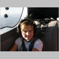
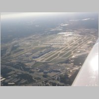
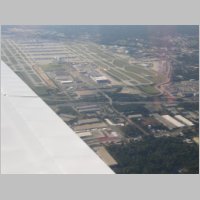
Flying
with the Big Iron
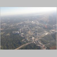
Enroute to the SouthEast side of Atlanta they routed me
right over town and right over the East approach end of the runway at
5000'. Very cool to see 6 or 8 of the big iron on your TIS display, all
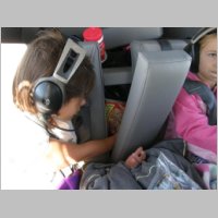
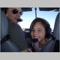
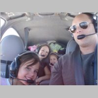
passing underneath you to land! The kids even took a break from their
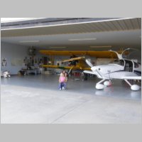
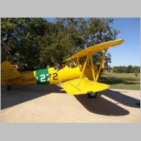
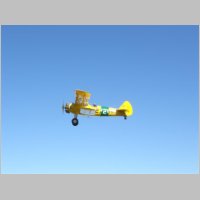
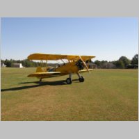
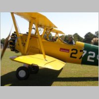
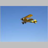
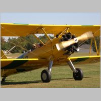
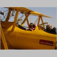
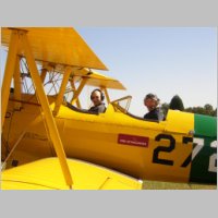
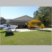
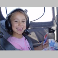
movies to look at all the cool planes passing below.Once on the ground we put the plane in Vic's hangar next to his Stearman that is currently going through sever withdrawl symptoms, sadly missing being parked next to an RV-10. I was a bit worried about the security of parking it in his hangar though....not from the riff-raff that may break in, but that perhaps Vic might try to pull it out while we slept and take it on a trip. I slept with the key under my pillow just in case. ;) The next day we were greeted with clear skies and great weather once again, and Vic had just enough time to get us out for Stearman rides before we left. Vic has one of the nicest looking Stearman's you'll ever see, and the kids just loved their rides in the open air. It's definitely an experience to be had, if you've never done it before. |
|||
 |
 |
 |
 |
 |
 |
 |
 |
 |
 |
 |
 |
 |
 |
 |
 |
|
Doing Disney
After our Stearman rides, we did a quick bit of shopping
for forgotten items and then we high-tailed it down to the Leesburg
area to stay with Andrea's parents, who we hadn't seen for a while. The
kids couldn't wait to get in a bit of swimming, and head to a
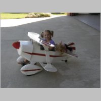
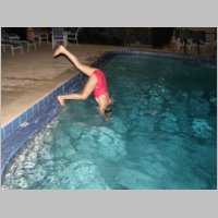
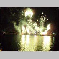
restaurant by golf carts.The next day we woke up and headed right out to hit 3 of the 4 main Disney theme parks....MGM Studios, Animal Kingdom, and Epcot. We've had good luck using Park Hopper tickets from Disney with the no-expiry option...with good deals to be had on 7-day and 10-day passes. It's nice because you can pay and buy the tickets and use them one day at a time and not be tied to one single park. We got to go see some of our favorite rides, and some new ones that we'd never been on. Danielle was especially lucky this time around, being able to match the 48" requirement for some of the wilder rides. One of the best times was on the river raft ride at the Animal Kingdom. It was great seeing everyone get soaked, and was good for cooling off. We got our family photo taken after the ride, making me look like we spilled our John bottle. ;) I had to shoot a photo of the girls by one of my favorite quotes from Charles Lindbergh, too... "What kind of man would live where there is no daring? I don't believe in taking foolish chances, but nothing can be accomplished without taking any chance at all." It kind of says what it takes to be a pilot, and especially to gain experience in flying in IMC. You want to manage the risk, but then accept it and gain some good positive experience. We stayed for the fireworks at Epcot and then went back to grab some rest because the next day was Sunday, and it was time to head home. |
|||
 |
 |
 |
 |
 |
 |
 |
 |
 |
 |
 |
 |
|
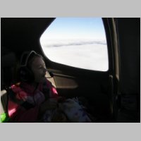
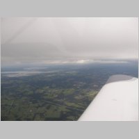
IMC
on the Return Trip
With as much fun as you can pack into a short weekend
done, we departed for my favorite part of the vacation...the IFR
portion. I was glad to see there were clouds on departure from KLEE,
and we would be in broken IMC at most any cruise altitude we
chose...4,000 - 6,000 - 8,000. I stayed below 10K on this trip
for more favorable winds and to cut our need for Oxygen when it
wouldn't benefit us. We had a very nice trip through the clouds,
droning along while they called un-seen traffic both oncoming, and
traffic we were overtaking. After a while I requested 8,000 and it got
a little choppy, but I stuck with it for a while and it ended up
smoothing right out again. Sure is nice to be able to make altitude
changes and not have to do them all with 200fpm climb rates! |
|||
 |
 |
 |
 |
 |
 |
 |
 |
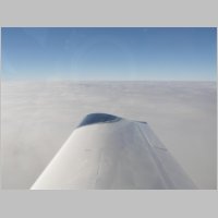
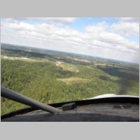
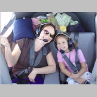
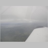
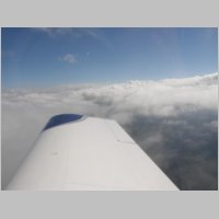
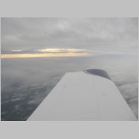
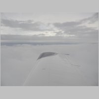
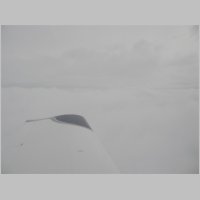
| I've
always loved the views you get going in and out of a nice smooth
stratus broken layer. It makes for great scenery and the kids
love watching the clouds go by. |
|||
 |
 |
 |
 |
|
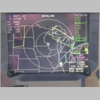
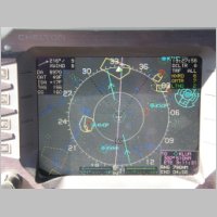
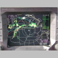
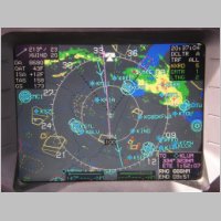
Looking Ahead
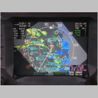
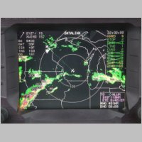
Now as we get closer, looking below at the Datalink page
on the Chelton you see we're going to be in for some questionable
weather on the final couple of hours on the flight. The Yellow boxes
are Airmets for Turbulence, the Red is Airmets for IFR, the Blue is
Airmets for Icing, and the Pink is Convective Sigmets. Looks like
we need to pick our line very carefully, and it's time for WSI to start
paying for itself. Scrolling ahead to read the textual Airmet on
that icing, it says that the freezing level is 8,000'-12,000' and we're
cruising right in the bottom of it, and the conditions aren't going to
change. Flying in IMC I regard as a very exhillarating experience, but
flying in ice is a whole 'nuther story. I'm not interested in that. |
|||
 |
 |
 |
 |
|
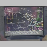
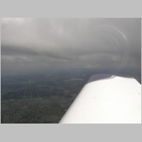
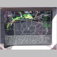
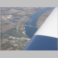
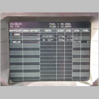
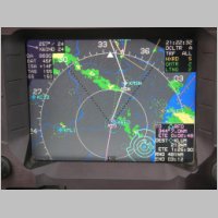
Stretching the Range
If anyone knows the name of the area by the bridge in the
photo below, I'd love to hear it. I didn't look it up as I flew
by. Looking at the additional screenshots below you can see the
convective sigmet is pretty active, with lots of lightning (the "+"
symbols) on that line. I was very relieved to see that there was
a hole along that main frontal cloud line that we could pass through
with less worry. I knew I'd have to be ready for some turbulence
and shifting winds though, and as we were going for range, stretching
our enroute time to 4 hours on a plane with 60 gallons of fuel, I kept
the mixture pulled back a little extra so we'd keep that burn down at
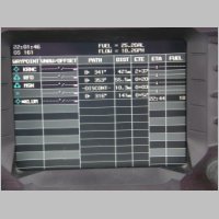
or below 10gph. You can see in the datalink photo below that our
destination would be 324nm with a ETE of 1:53, and with the mixture
pulled back we had a range of 663nm and a range time of 3:51, so we'd
gained so much range by running LOP that we'd have a 2 hour fuel
reserve if we could stay LOP. But, you always have to remember that
once you descend, you'll go ROP again and you'll need to accomodate
that higher fuel burn into your range planning! The NavLog page below
shows that at present burns and on present course, we'll land with
about 21 gallons of fuel left. Not bad for a 615nm flight leg to have 2
hours (300nm+) additional range in the plan. |
|||
 |
 |
 |
 |
|
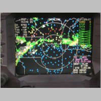
Checking the Wx
As we further get closer to the weather, our current path
was going to take us through the end of that area of green/yellow rain,
and knowing that the convective sigmet was part of that whole string of
clouds, I figured it's best to give it as much leeway as we can.
Time for a slight reroute. So I had them update me to Present Postion
direct RFD direct MSN direct KLUM, which should give me a little
further distance from the main part of the rain, threading through the
gap. I've found that usually the green areas are nothing much, as long
as they aren't surrounded by yellows and reds, and even yellows aren't
usually too bad, but if there's red around you need to be extra
cautious and give a little more leeway. The last shot on the row
below shows the Graphical Metars on the Datalink page, where you can
now see how many LOW IFR (Red) areas there are and how many IFR
(Yellow) areas there are. As it turned out it was plenty IFR at
my destination also. We were able to pick up a textual TAF on a nearby
airport while enroute and see what the forecast was. Very sweet. Also,
I turned off some of the airmet/sigmet things and turned on Echo Tops,
and you can see that there are lots of 25-30K' tops in that line, but
it does go up to 40K or more also if you look down by the most nasty
weather. Glad I was able to get up here early enough to beat that
stuff! |
|||
 |
 |
 |
 |
 |
 |
 |
 |
|
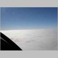
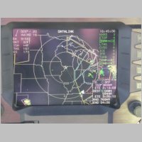
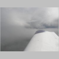
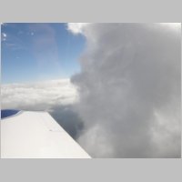
Passing through the Front
As we got into the RFD/MSN area of the flight, we started
to gather a full undercast layer again, and were between layers for a
while. I consider this type of weather the absolute most fun of all for
flying. Stuff to keep you on your toes, but yet you're flying in nice
soggy stratus layers to give you plenty of time in IMC to gather
experience without all the bumps. It's also beautiful when you can look
out the window between layers and see a little, although you have to
remember not to use the cloud layer as a horizon reference because it
isn't always level! Below you see another map view shot and can see how
intense the lightning is in that area of storms. As we passed through
the frontal clouds, the winds shifted by 25kts. When we entered the
clouds, we asked for a quick vector to cut through that front at a 90
degree angle to get out of it quick. But, with the known processing
delays that NexRad has, we suddenly got our latest 5minute update and
saw that the shape had slightly changed. Oh well, it was only a couple
minutes and it only got a little bumpy, so we rode on through. Now,
with 114nm showing on the distance to destination, it was time to take
the plunge. From here on in we were not only solid IMC, but the
temps were dropping too. Time to sit up straighter and fly right, and
make sure that pitot heat was on and working well. The fuel remaining
had changed to 18 gallons on arrival, but I had not yet loaded the full
approach that I knew I'd need. Always keep in mind that you need to
factor in fuel for the approach, and even extra extra fuel if it's low
because you may very well need to miss and go elsewhere. The IFR fuel
reserve requirements are not overly conservative, but that doesn't mean
you can't be. |
|||
 |
 |
 |
 |
 |
 |
 |
 |
|
Home Stretch
Finally from the datalink photo above you see we're home
free, but the picture doesn't tell the whole story. While there was
nothing there to show that it was raining, it was 100% IMC all the way.
Cruising at 8000' the moisture flowed over the windshield and wings
like a river, but there wasn't the sound of rain, which is why it
wouldn't necessarily be displayed on a NexRad image. It was just a
solid sky of juicy clouds. Keeping a close eye on the OAT, we continued
on at 8,000', knowing that the further north we'd go the closer to
freezing we'd get. This leg was filed while on the ground at KRNC,
using FSS, and I had them check the freezing levels for me. MSP, which
is nearby, was showing 5,500', so I knew that it would be likely I'd
have to ask for at least 6K, if not 4K, to maintain below freezing
temps. I was also hoping there wasn't any kind of temperature inversion
going on that was artificially keeping my OAT's high. We droned along
watching the OAT go down to 36F and then I called and asked for lower.On OAT Probes
Note that for those of you who are flying IFR, I hear WAY
too much talk about how people are planning to mount OAT probes on the
belly, or in a NACA duct. This is 100% not good enough for these flight
conditions. Any engine heat escaping out the inlets, or from the
exhaust, will be directed over an area near the fuselage, and we know
from past information that air actually can flow OUT the air inlets,
near the prop hub. All this air is going to go somewhere aft, and if
your OAT probe isn't somewhere OUTSIDE of the prop arc, it's not going
to be 100% accurate. Mine is located near I believe the 2nd wing
inspection panel on the bottom of the wing. You want it located out of
the sun, in the airflow, and out of the prop/exhaust wash. Think about
it, if your OAT is even off by 1 or 2 degrees and reads high, you will
be flying in ICE before your probe tells you it CAN ice. And if you
think ice is rare, remember that even in the summer the OAT's at
altitude are often below freezing, as my Niagara Falls trip showed,
seeing OAT's in the 20's in the middle of summer. The Chelton system
takes this matter seriously enough that it gives you a
compressibilty/heating factor that you calibrate in, trying to
accomodate for how the OAT reading changes due to the velocity through
the air and the slight heating it causes. My thought is, if you're
really that lazy that you want to mount the OAT probe on the fuselage
or in a NACA vent, just make it REALLY easy and mount it inside the
plane behind the panel....because even though it won't read accurately
there, you'll know it isn't accurate and you won't trust it. Keep in
mind that your True Airspeed readings are also dependent on an accurate
OAT, so if you're not going to take the time to calibrate your OAT
probe and have it read accurate, your speed readings are also not worth
reporting.Vectoring around some restricted airspace, we had an intersection to navigate to that provided a perfect opportunity. The best way to load an approach is to have a waypoint between you and the destination, and load the approach prior to crossing that point. The reason for this is that loading the approach will replace the final leg of the flight with one that navigates you to the IAF and for the approach. So using that intersection as the jumping point, I got on the radio and requested the GPS (WAAS) RNav 27 approach to KLUM, which has LPV minimums of 250'. Finally, a use for all that expensive approach gear! For those who think WAAS is coming slowly, I assure you that if the right people ask and pursue it, your small airport will likely get a WAAS approach on a short timeline. Ours is brand new, and it's great to have. With the approach loaded about 95nm from home, our fuel reserves changed a bit, adding a couple gallons for the 20 additional miles an approach can consume. We got all of our descent clearnances at the right times, dropped it down and once we hit the IAF we were heading in for the approach. The weather was low, but not extreme, as we eventually broke out at about 700'. "Breaking Out" was a relative term on this flight though, because it wasn't so much "out" as it was just descending into haze instead of full clouds. All we could see was the PAPI lights, and not even the runway lights that we lit in advance. As we neared the airport and got down to 400', it was clear enough to see the entire airport area with maybe 2-3 mile reasonable viz, and we made a good landing and put the plane away. The photos above and below show the conditions. It was evening, and it was raining and cold on the ground when we got there...kind of what it was when we left, but with rain. I guess, it's good to be home, but add 5 or 10 more degrees and this is my favorite flying weather. ;) |
|||
 |
|||
|
Running
the Numbers
All in all we used about 156 gallons of fuel, in 14.4 hours of time, for an average burn of around 10.85 gph. Our total cost was about $580 for the fuel, which averages the price down to $3.71/gal. The short estimate on flight distance is 2162 miles, not allowing for approaches and deviations, which brings the economy down to about 13.8 NAUTICAL mpg, or 15.9 mpg for the trip. Not super excellent, but pretty good considering our low (8-9,000') cruising altitudes. Much better economies can be had by flying 12-15K' if you want to use Oxygen. To REALLY put it in perspective though, you need to compare the costs and distance to the DRIVING distances and costs. Had we driven the car, we would have spent about $416.41 in auto gas, but spent 39 hours on the road as opposed to 14.4. The driving distance would have been 2882 statute miles, so if I take my 156 gallons of gas and fit that to automobile distances, my effective fuel usage was 18.42mpg. On the final leg of the trip, through LOP flying, I was on the ground with just under 17 gallons remaining, and at no point on the trip did I land with less than that quantity. Thanks to Voyager and fuel stop planning, I not only saved a pile of cash on fuel, but I did something I couldn't do with my old favorite....AirNav. I was able to actively re-route myself when fuel was unavailable as planned, and find suitable nearby cheap fuel. This is one good reason never to stretch your range if you're into fuel-price-based planning, as you may find you need to continue on to another airport. Once again, I spent over 2000nm thinking how wonderful it is that Van's came up with the RV-10, and feeling great about my choices in comfort and equipment. A plane's construction is not a one-size-fits-all thing, but I sure find that this plane fits my needs absolutely perfectly. |
|||