First IFR/IMC Flight with the RV-10
Added 8/8/2006 - 106.4 Flight HoursThis was the trip I'd been waiting for. I built the RV-10 to enable some great cross-country trips, safely, for flights under IFR rules and in IMC conditions. I equipped it with the best I could, and wanted to be able to use the gear for what it was designed. I hadn't flown in IMC conditions for those first 100 hours, partly to enable myself to become very familiar with the plane, and partly due to the lack of such weather this year. But here was a perfect chance...warm temps, no ice, wet clouds, high-enough ceilings, and a fairly short distance to travel (about 185 nautical miles). The trip was to go to a wedding, and required an overnight stay. Departure day there was a looming storm with hail that was heading across the state. We'd be flying well ahead of it, but there was the uncertainty of how the plane would weather the storm sitting on the ramp at KETB. In the end, we said "Go", with this rationale: We built the plane to fly, and to fly on non-perfect days. I know there will be a day when we land and wait out a storm, for safety's sake. So we need to get used to the idea of leaving an expensive plane in harms way, because you just never know what will happen....but fear of the consequences of flying your plane and leaving it places will quickly handicap you and reduce the utility of your newly built ride. So it was time to face those unknowns and enjoy our weekend.
On the trip over, we had a short period of poor conditions as we rode through a small but bumpy green patch of rain. A few minutes later, we were in the smooth clear under an overcast, keeping the sunlight out of our eyes. The trip was uneventful and we got to give some rides once we got there.
The trip home was where it was all at, for me. We didn't have any net access in the a.m. at the house, so the weather channel had to suffice. Let me tell you, I've heard that WSI weather is what the flight service stations use (and it's what I have in my plane). I've also heard that TV stations usually don't use the same weather, but is more similar to XM. I'd love to hear from someone who knows the details on this. But anyway, the Weather Channel weather showed some good sized storms coming across our area, and it required an early departure to beat them. When I got to the airport, however, I found that the storms on the Briefing PC looked much more ominous...and there was much better detail. There was hail in them there clouds, and we needed to get out of Southern Wisconsin if we didn't want to face it. A verification call to the briefer verified that within the hour, we'd have the storm arrive, so it was either time for a departure within 30-45 minutes, or an extended delay that could have us waiting for hours. We were all ready and could be off in ten, so it was time to file the IFR plan and go. A direct route would take us through the leading edge of the storm, as we were traveling North-Westerly, so we filed more Northerly to OSH (gee, wasn't I just here?) and then direct KLUM.
The rest of the story will be mixed in with the photos...
|
|
|
|
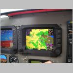
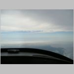
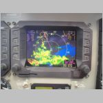
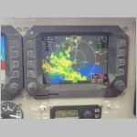
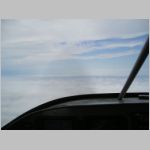
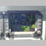
| The takeoff out of ETB was non-eventful, but was done in rain. The shots above show the Nexrad picture that was on our screens as we departed. Today I'd opt to throw those engine gauges over on the co-pilot screen (I usually take off with them in the center), to keep my eyes on the course and the weather. You can see by the course line that we were heading in directions that would work with the approaching weather. Had it not been for the in-flight WSI, I would have been much less comfortable with the unknowns of where the weather was. See and avoid, that's the way to do it. It didn't take long in the -10 to climb to our assigned cruising level of 6000'. I didn't file too high to avoid any real turbulent cloud tops, so for this trip we decided to run ROP (Rich of Peak) and just pay the piper for some fuel at 13gph+. I try to only run LOP (Lean of Peak) if I can cruise at 7500' or higher. At 6000', we had a smooth ride, above a widely scattered undercast, with a looming grey mass off to our West. | |||
|
|
|
|
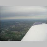
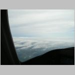
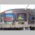
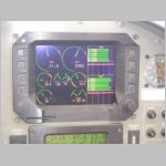
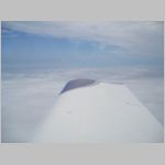
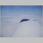
| As we approached our turn fix over OSH, I shot a few photos of the weather we were skirting, and some other shots of the screens for performance data. On this trip, I saw speeds as high as 172kts in cruise, but average was around 163kts. I'd rather have 155 with 10gph, but oh well...another day. | |||
|
|
|
|
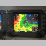
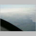
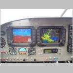
| Looking below, the airspace of a restricted area is visible. The nicest thing about this whole arrangement is the spatial orientation you get when you get weather, airspace, and navigation info all on the same screen. The controllers were very busy, and I actually got a couple of extra "thanks" out of two of them for being able to get by with minimal work from them. I made it a point to clearly state my intentions, and they then knew exactly how to fit me in. For instance: "We're heading direct OJYAB for the GPS-27 at KLUM"...controller: "We'll need to hold you for inbound traffic, can we hold you on your inbound radial?"...me: "Sure, I'll hold as published, East of OJYAB and get an EFC anytime you can.". They love it when they know someone is prepared. Having the entire approach drawn for you on-screen really helps a lot too. It drew the fixes, it drew the hold, I flew to the fix and flew the hold. Paper charts are ok, and great to have on hand (more on that later) but having it all on the screen next to me was great. Not only that, but having remaining time and remaining endurance time of fuel handy is great too. (also more on that later) | |||
|
|
|
|
|
|
|
|
|
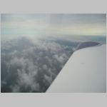
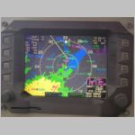
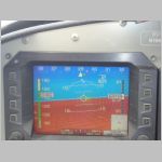
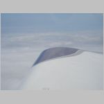
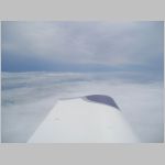
So you can see from the photos above, after we were north of the weather, we ended up on top for the rest of the trip. The kids played Uno, oblivious to the whole situation Luckily?, we got to do our hold and approach in the clouds (I was really looking forward to that), and had an easy final as we broke out at about 1600' agl. I was hoping for more like 800', but it was a great safety margin for my first approach in the -10. The last photo shows the datalink page where I put graphical METARS on the screen so you could see which airports are VFR (Blue), MVFR (Green), IFR (Yellow), or LIFR (Red) Great stuff to see trends in ceilings at a glance. | ||
More trip notes:
The trip was ALMOST uneventful. Before departure for the return trip, I stood in the rain while they added 10 gallons to one of my tanks. I didn't have them spread it evenly, as I didn't want to waste more time fueling, and didn't want to get water in both tanks, if it were to happen. To date, I've never had water in my sump, even after having it sit outside in heavy rains at OSH, but with the cap off for fueling I though it could happen. I learned a valuable lesson that I already (kind of) knew. As we were flying home, I noticed the fuel in the Left tank seemed to be dropping quicker than I thought it should. There were no fumes in the cockpit, so I knew it wasn't a leak in the cabin. We switched to the Right tank to verify we had a leak on the Left, and right away I had already assumed the conclusion. Sure enough, after a while it was easy to see that the level was dropping gallon by gallon on the Left, and I knew why. I sumped the tanks in the pouring rain. There was stuff dripping everywhere. I've never had a tank sump stick before, but I knew it was always possible. I knew that with all the dripping water, I had missed the fact that my sump was stuck slowly leaking. Sure enough, upon landing, there was a slow stream coming out, and a quick pop of the sump stopped it. I did not do anything different in-flight but monitor fuel closely, and even though I had this leak, my Right tank had over 1:00 of fuel left when we landed. I could have landed along the way and fixed it, but I was pretty sure I knew what the cause was, and a landing would have brought us to do an approach at a less familiar airport, in worse conditions, and the fuel lost in the climbout back to altitude would have been as much as the fuel lost enroute. With less than 1 hour remaining when we caught it, I pressed on. Had it been a longer flight, I would have looked for a good spot and landed right away, but seeing as we were going to land with about 8 gallons on the Left, even with the leak, and we only lost about 5 for the flight, it didn't pay. So, check those sumps even closer when it's raining....that's the lesson of the day.
December 2010 update: DO NOT BUY ANY OF FLIGHTPREP's PRODUCTS!!!! You will be supporting a company that is working towards the demise of many valuable internet resources!
Charts:
I will try to write on this later, and include photos on a future trip. At OSH, one of the few purchases I made was Golden Eagle Chart Case Express for the tablet PC. Yeah, I had a method all ready to have approach charts for free, but I still didn't have Low-enroute, sectionals, WAC's, or any of the other charts....and buying them before major trips is a pain. Plus, you never know WHERE you're going next when you have an RV-10...it's so capable of long flights, I wanted to be ready for any flight. Another side benefit was that although I had a GPS street map program that worked on the tablet, I didn't have any in-flight GPS tracking program for the tablet. It would make a nice entertainment device for the kids in the back. So I ponied up the $395 for Chart Case Express and it's looking very nice. I always flight plan in Golden Eagle Flight-Prep anyway, and those routes can be loaded directly into Chart Case Express. Chart case Pro includes the flight planning in the same software, but costs more, so I went with Express. On the way down for this trip, we tracked our position on a Low-Alt enroute chart for the poor weather time, and then gave it to the kids. They were thrilled to be able to watch our enroute time count down, and see how close were were getting. On the way home, we tracked our position on the Low-Alt chart, and then kept the tablet...more for practice than anything. But, we knew we were going to fly an approach into KLUM, so why not pull it up on the tablet and see how it goes. With the large area buttons on the software, it works very well in light turbulence, and it makes it easy to pull up charts...easier than anything else I've used. Andrea pulled up my approach chart for me, and we had it handy to refer to while doing the approach. I now know it was a good choice to buy, and will probably go ahead and pay for the updates as time goes on. It came with 13x updates so I'm good for a year. I've also subscribed to the Jepp NavData and Obstruction database on my Chelton system, and will probably get an occasional or possibly subscription for the GNS-480, but that one will be harder to justify, considering I have 2 current databases in the plane already.